
| By Big Radio News Staff |
Keep your eyes peeled for flooding along the Rock River over the next week.
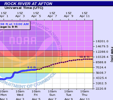
We haven’t seen it in Rock County since 2019, but the National Weather Service predicts the Rock River could enter minor flood stage by midday Friday.
And if predictions hold, it could top 10.5 feet at Afton by Wednesday. That would create borderline moderate flood conditions, the National Weather Service says.
Rock County’s Emergency Management Director, Kevin Wernet, says county public works crews are bracing for the threat of some road flooding at low spots along the river. That’s as more rain is expected this weekend alongside continued snow melt in the region.
When the river reaches 10.5 feet at Afton, floodwaters begin to cover parts of South River Road on Janesville’s south end, and Riverside Park on the city’s northwest side. People also would see some low farm field areas near Afton significantly swamped.
Wernet says county crews are ready to place “high-water” and “road-closed” signs at some roads.
Wernet says parts of the Rock River and even stretches of roadway can get hit by flooding differently each time the river floods.
He says some stretches of low roads that have historically gotten swamped during minor and moderate Rock River floods might fare differently because some of the spots have new, more efficient box culverts the county installed in recent years.
The river levels in the coming week are predicted to be 4 to 6 inches lower than surges that would cause more widespread area flooding, and they’d be well below the 13-foot surges at Afton that led to historic flooding in winter and spring of 2008.
Wernet also notes predicted flood crests can change. He says the emergency management division will continue to monitor conditions and upgrade a response as needed.
For now, it’s most likely the county’s main measures would be to place signs that warn motorists of high water over roads.
But already on Friday morning, an updated forecast showed river levels could remain on an upward trajectory through at least Wednesday.
Forecasters also call for a 90-percent chance of rain Sunday, although extended forecasts show we could remain rain-free most of next week.
Emergency officials advise motorists to never drive through high water covering or flowing across a road.