
| By Big Radio News Staff |
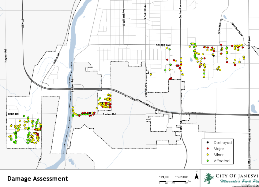
A city of Janesville damage assessment shows the tornado that struck the city’s south side destroyed three homes and severely damaged about 58 other residences.
The city generated a damage map using a walking survey of the three-mile swath of destruction the tornado left on Saturday. It shows the twister tore northeast on a diagonal route from Avalon Road to Kellogg Avenue, mangling trees and blowing a few houses off their foundations.
The survey shows winds from the twister hit four different neighborhoods on the south side. The map is marked with dozens of dots showing properties with damage ranging from minor damage to severe damage to total destruction.
Between Janesville’s south side and the town of Rock, surveys show 236 homes have damage ranging from minor to severe, while another 93 homes saw minimal impact from the tornado.
City spokesman Nick Faust says the city continues to update the map. It’s based on FEMA standards for tornado damage. Faust says for volunteers who’re helping clear properties of blown-down trees and debris, the new map is a helpful tool to see the path of the tornado and identify what neighborhoods got hit hardest.
The markup shows the greatest destruction was along a stretch of Avalon Road just east of the Rock River.
That area represents a quarter-mile swath about three city blocks wide. Within it, the city’s map shows 18 houses with major damage, and about 40 with minor damage.
Earlier this week, the city had estimated the tornado caused about $20 million in damage.